The River Parrett – how it works

Rivers that discharge into the Severn Estuary are very different from most UK rivers. With a tidal range in the estuary of around 11m  MLWN -3. 0 and MLWS -5.7 AOD and the river bed level at around 0.00 AOD.  These levels means that at low tide in the estuary the water level is always below the bed of the River Parrett and the river simply empties into the estuary. In the case of the Parrett its a process that goes as far upstream as Oath and the changing tide sees the river refilling from the sea.

What is seen looking over the Bridgwater’s bridges is just one half of the normal tidal cycle you would see at the coast; at low (ebb) tide its purely fresh water going out and that can be seen on the West Quay tidal gauge where the graph flattens. Equally the point at where incoming seawater (saltwater)  takes over from the  freshwater of the Parrett and becomes  a relatively small component of the rivers water can also  estimated.

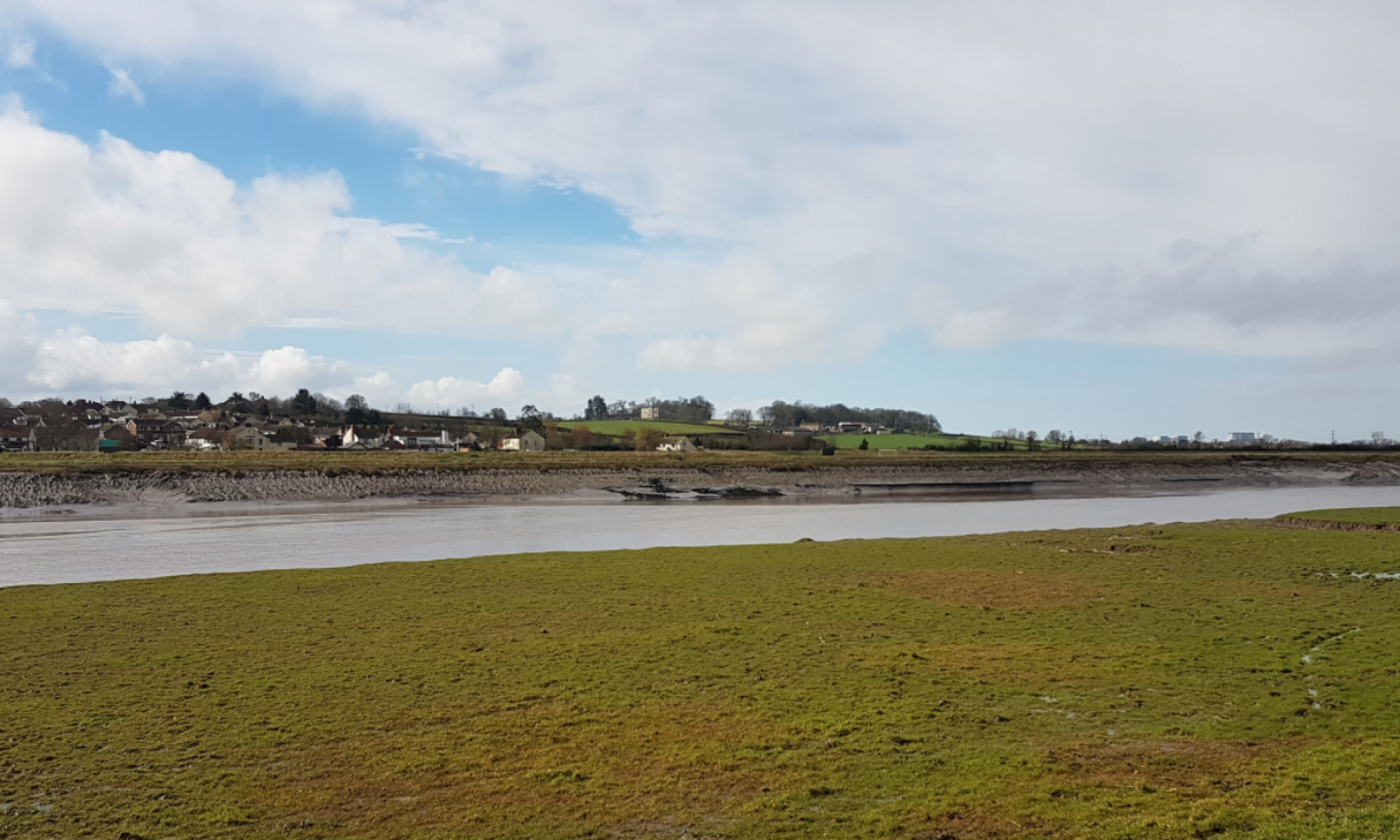
At low tides the river empties so completely that during periods of low fluvial flow it can actually dry out so much so that upstream of Combwich there is an old iron age path where people simply walked across the river at low tide.

High tides can be nearly 2m above the surrounding land and at Bristol Road nearly as high as the head of the doors and over the next hundred years that will  continue to grow .

Ecologically it is largely a  dead river. Nature likes, however bad, a consistent environment and the Parrett offers the greatest of changes twice a day from empty to full and freshwater to saltwater. The large amounts of Seven Estuary silt that arrives with the tides exclude sunlight and there is nothing to generate oxygen. Fish(salmon) and Elvers just transit the river on their way to the fresh water of the River Parrett and its tributaries.

It is a true challenge for The EU Water Framework Directive as  there is little negative actions that can be done to it. The lack of water does not deter unrealistic claims that fisheries exist in the river.

The images below show River Parrett tides ( courtesy of  GaugeMap)

West Quay One days Tides
West Quay One weeks Tides
HPC Tide Gauge

The Hinkley Point tide gauge above shows the full cycle of the tide in compoarison to the truncated cycle at West Quay which is caused by the river bed being higher than the sea bed in the Seven Estuary.

West Quay- One Months Tides

Looking along the river it could be shown

River Parrett at Low Tide

2014 Flood

In 2014 the Somerset Levels flooded, normally excess water is stored on the levels and then pumped back into the river  when the weather improves and fluvial flows have reduced. The floods occurred because the flood storage capacity  of the land was exceeded.

The response to the flood and still the current plan is pumps some more fixed ones and temporary platforms for hired pumps such as the permanent platform at Dunball made ready for the next time the levels flood and improvements made to how fast the flood water can be drained off the Levels.

One important question is whether its  possible to increase the  amount of water that flows  down the river without pumps? 

The answer is yes;  the Thames Barrier is used in that way when there is flooding and the Thames and its tributaries are at capacity. The barrier gates are closed at low tide creating a shallow reservoir normally filled by the incoming tide and floodwater coming down the river fills it up. Previous references to the Thames Barrier and the River Parrett were in relation to the type  of gate rather than how the system operates.

How might it work in the River Parrett?

There are two sources of fluvial floes into the Parrett. The Parrett and King SedgemoorDrain (KSD) /Sowy River.  Water unable to get down the River Parrett is diverted around Bridgwater via the KSD/Sowy and re-enters the Parrett at Dunball.

Dunball Clyce (River Parrett side)

Both  sources can discharge when the tide is out  but become tide locked when the sea re-enters the river.  Creating a large temporary empty length of river downstream of Dunball would allow both sources to continue flowing and when full and matched with the tide allowed to go to the sea.

River Parrett – Increasing the Flow

To do this a gate is needed downstream of Dunball and the best location would be Combwich or somewhere in between.  The Bridgwater Tidal Barrier is a gate that could  have been used to do this.

EA  Downstream  Scheme 

The   current plan is to build the Bridgwater Tidal  Barrier upstream of Dunball Clyce and with sea and tide levels continuing to rise  allowing the sea to reclaim the farmland  at Chilton Trinity and Pawlett Hams.  The existing  system returning to an inter tidal saltmarsh/mudflat covering the existing farmland at Pawlett Hams and most of the land to the north of the village of Chilton Trinity. The drawing below shows how the regime will change over the years to come.

River Parrett at Chilton Trinity & Pawlett Hams showing planned next 100 years

The information can be found in

The Parrett Estuary Flood Flood Risk Management Strategy

Full copies of the EA policies can be found at

Steart Peninsula (Stolford to Combwich) 7d34 to 7d37

Parrett Estuary (Combwich to River Brue) 7d38 to 7d42

further information with flood maps can be found in the article on

Chilton Trinity and Pawlett Hams


Somerset’s 20 Year Flood Action Plan is not a Plan

Has anyone noticed  there actually isn’t really a plan for managing flooding in Somerset  be it Tidal or Fluvial. Lots of headlines and pictures of grandstanding councillors on river banks  but little substance.  Our particular collective flood Emperor has no clothes whilst the myth that somehow the Bridgwater Tidal Barrier (BTB) is part of the solution to the avoiding a repeat of the 2014 flood is allowed to persist. People imagine that things are being done and there is a big picture somewhere. There isnt.

The Somerset 20 Year Flood Action Plan is little more than a  maintenance list that should have been done and wasn’t; it is a complete misnomer. In three years since the 2014 flood  there is no  big plan looking forward  the next 200 years. There is no context that  explains where the value of all the money being spent is.

There is no excuse for such short sighted behaviour by our officials and elected representatives. At least the Somerset Rivers Authority (SRA) carried out an economic impact assessment of the 2014 flood which is more than the EA and Sedgemoor District Council (SDC) have done for the Bridgwater Tidal  Barrier.

The development of new ideas  seems to be more akin to those seeking alternative medicinal remedies; they seem to be ones that will turn the Levels into some theme park rather than look at something that can be delivered over the decades and centuries ahead. The  Managed  Retreat (Realignment) of our coastline is not a panacea to rising sea levels; it has its place but  needs to be challenged when there are viable options.  Giving the EA the excuse and licence to do little or nothing is not acceptable. Those involved with W&WT and the RSPB as consistent beneficiaries of these  EA policies and alongside Natural England makes an unholy alliance  that is no friend of Somerset’s people.

Plenty of councillors are sat on committees and they should be ensuring rigorous debate and the publishing of useful information rather than the almost complete lack of detail in the public domain. The private sector would not be allowed to get away with this lack of transparency or vision.

Since 2014 when it was rushed together for political expediency  little has been done or achieved whilst show case projects are not what they seem

Bridgwater Tidal Barrier

Despite knowing that  the rise in sea level  has no recognised end date Somerset has decided on a  100 year scheme. Our King Canute moment.

We are going to build a scheme that cannot be easily extended or modified knowing full well that something else will be needed in the future but we haven’t decided what. A scheme that  unlike any conventional tidal surge barrier  it is  actually to be in the town rather than down stream and at the mouth of the river. Bridgwater in  probably 10 rather than 100 years will have enveloped the proposed barrier site.  A solution with built in obsolescence that  can be bypassed on day one does not seem a great idea. Children born today may see the BTB torn down. Why would Bridgwater  buy it?”

Options such as closing the gap between Stockland Bristol  and Pawlett Hill less than 2 Km  ( 1.3 miles) long compared to around 15 km (10 miles) both banks from Combwich to the selected site in Bridgwater or 7.5 Km  if you allow Pawlett Hams to go the way of Steart Peninsula.

Two option studies paid for by the taxpayer and Combwich  not even considered as an option in either and the  backdoor flood route at Walpole still not acknowledged when the EA visits landowners. The credibility of the EA , its consultants and our oversight committees is very poor.

King Sedgemoor Drain Improvement

The King Sedgemoor Drain improvement is a Fluvial conveyance scheme that cannot reach its full potential because of the location of the tidal BTB upstream of Dunball Clyce. The EA in this matter described themselves in recent correspondence as the SRA’s sub contractor.

Silos

Flood schemes are kept in silos of fluvial and tidal rather than in developing a single holistic solution for Somerset. The EA and other organisations make it very difficult  to see the full picture. There is a serious lack of transparency,  accountability and independent review in the process.

By 2024 nearly £100m will have been spent and the Levels will still flood. The Bridgwater Tidal Barrier is seen and portrayed as a Bridgwater only scheme where as moving it downstream  of the KSD outfall would increase conveyance  under fluvial conditions benefiting the districts of Taunton Deane and South Somerset. The SRA is nowhere to be seen generating debate and  bringing together people to achieve a wider benefit to Somerset with state and local ratepayers money which was its reason to be created. The SRA’s one big opportunity missed. This is notwithstanding the missed economic opportunity for West Somerset

Transparency

There is more information in the public domain about EDF’s Hinkley Point C power station then there is about these schemes especially the Bridgwater Tidal Barrier. It appears  the EA did not want the Chilton Trinity  and Pawlett Hams landowners to be aware of  what would not be done to protect their land choosing to hide behind the rather opaque Parrett Estuary Flood Risk Management Strategy. Something noticeably low key to the point of invisibility  in the EA’s 2016 consultations at the Bridgwater Art’s Centre.

The reasons  that undertakings given by the EA and SDC in Protecting Bridgwater and the Somerset Levels & Moors from Tidal Flooding-Flood Risk Management Review -November 2014 were never followed through and just quietly dropped has never been explained.

No imagination  and no vision for our children’s future

With a blank sheet of paper and little or no restrictions on what we might do to protect the South Somerset Levels including areas of Sedgemoor, Taunton Deane and  South Somerset there is still a blank piece of paper. Rarely has such an opportunity been squandered.

There is nothing that explains what happens to the Tidal Surge Barrier when we cannot raise the banks any longer which in reality we cant now and Pawlett Hams and Chilton Trinity have become mudflats/ salt marsh  and the cost of building downstream  prohibitive.

What we do have is lots of committees

Wessex Regional Flood and Coastal Committee (RFCC)

Board of the Somerset Rivers Authority (SRA)

SRA Joint Scrutiny Panel

Somerset Drainage Board Consortium (IDB)

Its interesting to note how many people sit  on more than one of these committees. These committees  have people with no engineering knowledge or experience apart from the EA & IDB and all EA’s donkey work is done by US and Canadian third party consultants with no attachment to the area. The EA’s contribution to Somerset is questionable now as they have been reduced to little more than a middle man.

we must also not forget the groups

  • SRA  Management Group
  • SRA Technical Group
  • Bristol Channel Strategic Coastal Group
  • South West Coastal Group
  • Southern Coastal Group

It really is time that Somerset had  a suitable organisation capable of bringing a long term vision to secure the future of Somerset. Whilst attendance at committees is so lucrative  nothing is going to get done .  The EA is not a delivery based organisation and needs to be changed or replaced.  The SRA has no structure or suitable people able to develop and execute the vision and solution we need. The system  we have is clearly not fit for purpose.

The situation for Somerset, the rest of the West Country and no doubt other regions of the UK is that they need their own independent Engineers with local knowledge. Engineers able  to provide continuity  in advice to the committees and oversee the EA and IDB and other agencies.

We cannot afford

  • that each agency (EA, Highways, Rail) continues to builds its own thing, we need to combine flood defence with other infrastructure works.
  • that strategic flood decisions can be left to seconded senior local authority officers  with little or no knowledge of the subject.
  • the lack of an independent peer review process.
  • The lack of transparency – there is nothing published on the BTB website that tells you why.  There is little value value in an undated progress report  that can be found there  that does not measure progress. 
  • all these organisations whose main purpose seems to be to invite people from other groups to attend their meetings at our expense.

WE NEED A PLAN and we need to end the Flooding Golden Goose. 

on the 14th of July 2017  a meeting of the Scrutiny Committee  will take place in Taunton . It is open to the public. 

http://www.somersetriversauthority.org.uk/about-us/sra-scrutiny-meetings-and-papers/


Why things go wrong.

I am currently in Shetland overseeing the rebuilding of some badly built concrete and reporting on the causes. One of the primary reasons for the situation is the multiplicity of organisations in the delivery process where people in those organisations chose to assume the “other people” whoever they were had looked at it and checked it.

The result was that a completely avoidable problem occurred. The details of the incident do not matter what does matter is the lack of knowledge and responsibility in the delivery chain. People assumed and did not have the experience to put their hand up or were overruled on issues that were clearly obvious if people followed normal practice.

The UK is seeing increasing local control of significant  long term infrastructure development passing into the hands of local councillors who have no access to independent advice. The low level of scrutiny and lack of third party review now being applied to tax payers expenditure is of great concern. LEP funding organisations seem equally poorly equipped accepting what the EA, Highways and other statutory bodies choose to tell them.

In 2016 I provided written evidence to the House of Commons
Environment, Food and Rural Affairs Committee Second Report of Session 2016–17. The concern being that important infrastructure projects being locally run did not have adequate over sight. Once local authorities had the District Engineer whilst central Government oversight is at such a high level and based in London that it is largely irrelevant to the population. We have no competent independent oversight on the many state funded projects taking  place regionally.

Recent correspondence with The Somerset Rivers Authority indicates that organisation has all the indicators of an organisation with inadequate resources and a scrutiny committees that appears to have no terms of reference and no access to third party advice. No large commercial organisation would operate in this fashion. It is noteworthy that the EA in response to recent questions describe themselves as a subcontractor to the SRA.

There is little doubt that there is some huge embarrassing and expensive mistake on the way. It is time the regions had independent Engineers who can advise our councillors and has the power to bring statutory organisations to the table. Someone who lives in the region who can drive solutions to the tax payers benefit rather than the continuing creation of separate infrastructure rather than integrated solutions.

As usual we have too many people in positions of influence who don’t know what they are talking about  and consultants more concerned with fee income than doing the right thing. Bridges on Tidal Barriers for instance.

If the regions want independence they will need the tools to do the work. Our infrastructure delivery needs to better managed and supervised.

West Quay Collapse

In November 2011 a section of Bridgwater’s West Quay collapsed. It was an old quay wall, possibly medieval in parts and close to or at the location where the demolished Bridgwater Castle  would gain access to the River Parrett. Whilst there is no official report explaining the failure it was probably the usual one;  a build up of water behind the wall that exceeded the ability of the wall to  resist it. It had rained very heavily beforehand. This is why holes are provided at the base of retaining walls to let the water escape and reduce the water pressure behind. Old walls often fall over and some relatively new ones fall over as well.

However since collapse the EA and Sedgemoor District Council  appears to have developed their own interpretation on the collapse implying that West Quay is a flood defence  which it isn’t. It was part of the old port of Bridgwater and the legacy of that commercial activity.

The EA’s public 1016 consultation boards on the Bridgwater Tidal Barrier imply that the West Quay collapse would not have happened if the Tidal Surge Barrier and its associated defences had been in place which  is implausible to say the least. It also makes a statement that the wall was in poor condition, who knows what condition it was in and a wall can be in perfect condition and still fall over if its capacity is exceeded.

EA Barrier Location Consultation March 2016
EA Barrier Consultation September 2016
Sedgemoor Draft Local Plan 2017

Sedgemoor ratepayer’s have been asked for comments on the location of the the Bridgwater Tidal Barrier in 2016 and the Draft Local Plan in 2017. They rely on the efficacy of the information provided by our statutory authorities and in the case of West Quay  the information and the story presented seems questionable.


A Tidal Surge Barrier, A Bridge & Dunball Wharf

One of the problems with building the Bridgwater Tidal Barrier downstream of Dunball Wharf is the marine traffic to Dunball Wharf. Sedgemoor District Councils current draft local plan states “The Council will support the continued operation and potential development of Bridgwater Port including Dunball Wharf and Combwich Wharf (Policy D16 applies). It will also support the re-establishment of active commercial wharf’s at suitable locations elsewhere on the River Parrett. In all cases the construction or operation of new wharf’s should not adversely impact upon the Severn Estuary internationally designated site.”

The reality is that  the Dunball Wharf’s with their tidal drying berths, dependency on  high tides and difficult navigation is never going to be a commercial success but the 200m wide river at Combwich might. Construction of  the tidal surge barrier could enable the relocation of Dunball Wharf to a better location.

Much hangs on what is considered to be adverse.

Concepts of what the river structures might look like have not been forthcoming since 2009. Apart from the tower  and turning vertical gate Bridgwater’s gate structure will be considerably shorter than the Hull Barrier structure we have  been repeatedly shown.

What would a barrier with a road bridge  options look like?

Another wharf at Combwich, EDF have  one there already, would not require an opening bridge or clearance much more than Drove Bridge on the NDR. A tidal surge barrier with a 40m fixed navigation span and a road deck might look like

Keeping Dunball Wharf  would require a one larger gate and an opening bridge. Dunball currently sees 40 or so vessel movements a year so its operation would not affect the bypass traffic.

The engineering is relatively simple and with a purpose built wharf everything could be shipped in during construction.